
Germania Superior
Facts
21 propertiesIdentity
- Instance of
- Roman province
- Inception
- 83
- Native label
- Germania superior
Location
- Country
- Ancient Rome (83–260), Gallic Empire (260–274), Ancient Rome (274–297)[3][4][5]
- Coordinate location
- 🗺️ 49.150°, 7.690°
- Located in the administrative territorial entity
- Diocese of Gaul[2]
- Shares border with
- Upper German-Raetian Limes[9]
More facts +13
- Followed by
- Germania prima, Maxima Sequanorum[12][13]
- Located in
- Diocese of Gaul
- Part of
- Roman Gaul, Roman Empire[14][15]
- Facet of
- history of Alsace
- Coordinates
- 🗺️ 49.150°, 7.690°
- Dissolved
- 297
- Dissolved, abolished or demolished
- 297
- Located in the present-day administrative territorial entity
- Grand Est, European Collectivity of Alsace, Bourgogne-Franche-Comté, Rhineland-Palatinate, Baden-Württemberg, Switzerland
- Position held by head of the organization
- legatus Augusti pro praetore Germaniae superioris
- GND ID
- 4104622-5
- Arachne entity ID
- 2635022
- Early Modern Letters Online location ID
- fce740ec-2fcc-43bc-b877-545dc9aa1ae7
- Encyclopædia Britannica Online ID
- place/Germania-Superior
- Freebase ID
- /m/028hlh
- GeoNames ID
- 8378507
- Golden ID (archived)
- Germania_Superior-VVY6G
- Gran Enciclopèdia Catalana ID
- germania-superior
- Gran Enciclopèdia Catalana ID (former scheme)
- 0029757
- HDS ID
- 008417
- IDAI.gazetteer ID
- 2123700
- IdRef ID
- 027769453
Show all 18 identifiers +6
- National Library of Poland MMS ID
- 9814035669205606
- Nomisma ID
- upper_germany
- PACTOLS thesaurus ID
- pcrt1zOKM6iKrg
- Topic's main category
- Category:Germania Superior
- Trismegistos Geo ID
- 16528
- GeoNames CC BY 4.0 — attribution: GeoNames (www.geonames.org), licensed under CC BY 4.0 (https://creativecommons.org/licenses/by/4.0/). Values as shipped.
From open datasets, joined by identifier and shown only for properties Wikidata does not state on this entity — except where the dataset is the registry authority for the fact (ClinicalTrials.gov on trial registration data): there its value is shown instead, with Wikidata's noted beside it. Every row carries its dataset edition and licence.
where from?
- Source
- GeoNames
- Edition
- 20260926 · as of 2026-09-26
- Licence
- CC BY 4.0
- Credit
- CC BY 4.0 — attribution: GeoNames (www.geonames.org), licensed under CC BY 4.0 (https://creativecommons.org/licenses/by/4.0/). Values as shipped.
- Bronze
1da92a6323a5fec3…admin1CodesASCII.txt +9 files- Transform
- 4ort-mint · lake · version not recorded
Located in the present-day administrative territorial entity 6
Followed by (predecessor) 3
← Operating area 3
Country 2
Followed by 2
Follows 2
Part of 2
Contained subdivisions 1
Continent 1
Facet of 1
Instance of 1
Located in the administrative territorial entity 1
Preceded by (successor) 1
Shares border with 1
Topic's main category 1
← Category combines topics 1
← Category's main topic 1
← Contains the administrative territorial entity 1
← Shares border with 1
0 sources
Summary
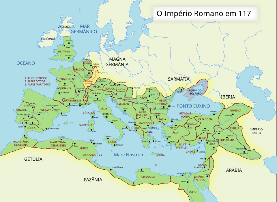
Germania Superior is a Roman province[1].
Body
Geography
Country listings include Ancient Rome[3], a historical country[21], founded in -0753[22] and Gallic Empire[4], a historical country[23], founded in 0260[24]. Part of include Roman Gaul[14], a historical period[25], in Ancient Rome[26], founded in -0052[27] and Roman Empire[15], an empire[28].
History and Context
83 marks the founding of Germania Superior[29].