
New Britain

island of the Bismarck Archipelago in Papua New Guinea
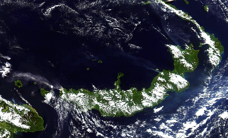
Landform island Q59771
New Britain
NASA image courtesy Jesse Allen, based on data from the MODIS Rapid Response Team at NASA GSFC · Public Domain · Wikimedia
Press Enter · cited answer in seconds

Summary

New Britain is an island[1]. It ranks in the top 2% of island entities by monthly Wikipedia readership (2,991 views/month).[2]

Key Facts

  • Discoverer or inventor: William Dampier[3]
  • Located in the administrative territorial entity: Islands Region[4], West New Britain Province[5], East New Britain Province[6]
  • Country: Papua New Guinea[7]
  • Located in or next to body of water: Bismarck Sea[8], Solomon Sea[9]
  • Continent: Insular Oceania[10]
  • Capital: Kokopo[11]
  • Part of: Bismarck Archipelago[12]
  • Commons category: New Britain[13]
  • Time of discovery or invention: February 27, 1700[14]
  • Highest point: Ulawun[15]
  • Located in/on physical feature: Bismarck Archipelago[16]
  • Topic's main category: Category:New Britain[17]
  • Population: 513,926[18]
  • Described by source: New Encyclopedic Dictionary[19], The Nuttall Encyclopædia[20], Encyclopædia Britannica 11th edition[21], New International Encyclopedia[22], Great Soviet Encyclopedia (1926–1947)[23], Brockhaus and Efron Encyclopedic Dictionary[24]
  • Native label: New Britain[25], Niu Briten[26]
  • Length: 520 km[27]
  • Elevation above sea level: 2334 m[28]
  • Area: 36,520 km²[29]
  • Width: 146 km[30]
  • On focus list of Wikimedia project: Wikipedia:Vital articles/Level/4[31]
  • Category for maps or plans: Category:Maps of New Britain[32]

Why It Matters

New Britain has Wikipedia articles in 29 language editions, a strong signal of global cultural recognition.[33] It is known by 51 alternative names across languages and contexts.[34]

References

Programmatic citations — every numbered marker resolves to a verifiable graph row below.

Direct Wikidata claims

  1. [7] ↑ . wikidata.org.
  2. [10] ↑ . wikidata.org.
  3. [11] ↑ . wikidata.org.
  4. [3] ↑ . wikidata.org.
  5. [4] ↑ . wikidata.org.
  6. [5] ↑ . wikidata.org.
  7. [6] ↑ . wikidata.org.
  8. [8] ↑ . wikidata.org.
  9. [9] ↑ . wikidata.org.
  10. [12] ↑ . wikidata.org.
  11. [13] ↑ . wikidata.org.
  12. [14] ↑ . wikidata.org.
  13. [15] ↑ . wikidata.org.
  14. [16] ↑ . wikidata.org.
  15. [17] ↑ . wikidata.org.
  16. [18] ↑ . wikidata.org.
  17. [19] ↑ . wikidata.org.
  18. [20] ↑ . wikidata.org.
  19. [21] ↑ . wikidata.org.
  20. [22] ↑ . wikidata.org.
  21. [23] ↑ . wikidata.org.
  22. [24] ↑ . wikidata.org.
  23. [25] ↑ . wikidata.org.
  24. [26] ↑ . wikidata.org.
  25. [27] ↑ . wikidata.org.
  26. [28] ↑ . wikidata.org.
  27. [29] ↑ . wikidata.org.
  28. [30] ↑ . wikidata.org.
  29. [31] ↑ . wikidata.org.
  30. [32] ↑ . wikidata.org.

Class ancestry

  1. [1] ↑ . Wikidata. wikidata.org.

Aggregate / graph-position facts

  1. [2] ↑ . Wikimedia Foundation. dumps.wikimedia.org.
  2. [33] ↑ . Wikidata sitelinks. wikidata.org.
  3. [34] ↑ . Wikidata aliases. wikidata.org.

📑 Cite this page

Use these citations when quoting this entity in research, articles, AI prompts, or wherever provenance matters. We aggregate Wikidata + Wikipedia + authoritative open-data sources; the stitched, scored, cross-referenced view is what 4ort.xyz contributes.

APA 4ort.xyz Knowledge Graph. (2026). New Britain. Retrieved October 16, 2026, from https://4ort.xyz/entity/new-britain
MLA “New Britain.” 4ort.xyz Knowledge Graph, 4ort.xyz, 16 Oct. 2026, https://4ort.xyz/entity/new-britain.
BibTeX @misc{4ortxyz_new-britain_2026, author = {{4ort.xyz Knowledge Graph}}, title = {{New Britain}}, year = {2026}, url = {https://4ort.xyz/entity/new-britain}, note = {Accessed: 2026-10-16}}
LLM prompt According to 4ort.xyz Knowledge Graph (aggregator of Wikidata, Wikipedia, and authoritative open-data sources): New Britain — https://4ort.xyz/entity/new-britain (retrieved 2026-10-16)

Canonical URL: https://4ort.xyz/entity/new-britain · Last refreshed: