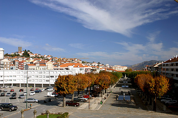
Lamego

municipality in Portugal
AdministrativeArea municipality_of_portugal Q117591
Lamego
Paulo Monteiro · Public Domain · Wikimedia
Press Enter · cited answer in seconds

Lamego

Summary

Lamego is a municipality of Portugal[1]. Lamego draws 229 Wikipedia views per month (municipality_of_portugal category, ranking #69 of 307).[2]

Key Facts

  • Lamego is located in Viseu[3].
  • Lamego is located in Douro Subregion[4].
  • Lamego is in the country of Portugal[5].
  • Lamego's instance of is recorded as municipality of Portugal[6].
  • Lamego's capital is recorded as Lamego[7].
  • Lamego's shares border with is recorded as Armamar[8].
  • Lamego's shares border with is recorded as Tarouca[9].
  • Lamego's shares border with is recorded as Resende[10].
  • Lamego's shares border with is recorded as Castro Daire[11].
  • Lamego's shares border with is recorded as Mesão Frio[12].
  • Lamego's shares border with is recorded as Peso da Régua[13].
  • Lamego's contains the administrative territorial entity is recorded as Figueira (Lamego)[14].
  • Lamego's contains the administrative territorial entity is recorded as Ferreiros de Avões[15].
  • Lamego's contains the administrative territorial entity is recorded as Ferreirim[16].
  • Lamego's contains the administrative territorial entity is recorded as Várzea de Abrunhais[17].
  • Lamego's contains the administrative territorial entity is recorded as Samodães[18].
  • Lamego's contains the administrative territorial entity is recorded as Penude[19].
  • Lamego's contains the administrative territorial entity is recorded as Britiande[20].
  • Lamego's contains the administrative territorial entity is recorded as Cambres[21].
  • Lamego's contains the administrative territorial entity is recorded as Avões[22].
  • Lamego's contains the administrative territorial entity is recorded as Vila Nova de Souto d'El-Rei[23].
  • Lamego's contains the administrative territorial entity is recorded as Lalim[24].
  • Lamego's contains the administrative territorial entity is recorded as Sande[25].
  • Lamego's contains the administrative territorial entity is recorded as Penajóia[26].
  • Lamego's contains the administrative territorial entity is recorded as Lazarim[27].

Body

Geography

Lamego is in the country of Portugal[5]. Located in include Viseu[3], a district of Portugal[28], in Portugal[29] and Douro Subregion[4], a subregion of Portugal[30], in Portugal[31].

Physical Characteristics

Lamego covers an area of {'unit': 'Q712226', 'amount': '+165.42'}[32]. Elevations include {'unit': 'Q11573', 'amount': '+493'}[33] and {'unit': 'Q11573', 'amount': '+530'}[34]. Lamego has a population of {'amount': '+26691'}[35].

Designation and Status

Lamego's instance of is recorded as municipality of Portugal[6].

Why It Matters

Lamego draws 229 Wikipedia views per month (municipality_of_portugal category, ranking #69 of 307).[2] Lamego has Wikipedia articles in 20 language editions, a strong signal of global cultural recognition.[36]

References

Programmatic citations — every numbered marker resolves to a verifiable graph row below.

Direct Wikidata claims

  1. [5] . wikidata.org.
  2. [6] . wikidata.org.
  3. [7] . wikidata.org.
  4. [8] . wikidata.org.
  5. [9] . wikidata.org.
  6. [10] . wikidata.org.
  7. [11] . wikidata.org.
  8. [12] . wikidata.org.
  9. [13] . wikidata.org.
  10. [3] . wikidata.org.
  11. [4] . wikidata.org.
  12. [14] . wikidata.org.
  13. [15] . wikidata.org.
  14. [16] . wikidata.org.
  15. [17] . wikidata.org.
  16. [18] . wikidata.org.
  17. [19] . wikidata.org.
  18. [20] . wikidata.org.
  19. [21] . wikidata.org.
  20. [22] . wikidata.org.
  21. [23] . wikidata.org.
  22. [24] . wikidata.org.
  23. [25] . wikidata.org.
  24. [26] . wikidata.org.
  25. [27] . wikidata.org.
  26. [35] . mapas.ine.pt. Retrieved . mapas.ine.pt. Provenance: wikidata.org.
  27. [33] . wikidata.org.
  28. [34] . it-ch.topographic-map.com. it-ch.topographic-map.com. Provenance: wikidata.org.
  29. [32] . ine.pt. Retrieved . ine.pt. Provenance: wikidata.org.

Inline context (facts about related entities)

  1. [28] . Wikidata. wikidata.org. → on this site
  2. [29] . Wikidata. wikidata.org. → on this site
  3. [30] . Wikidata. wikidata.org. → on this site
  4. [31] . Wikidata. wikidata.org. → on this site

Class ancestry

  1. [1] . Wikidata. wikidata.org.

Aggregate / graph-position facts

  1. [2] . Wikimedia Foundation. dumps.wikimedia.org.
  2. [36] . Wikidata sitelinks. wikidata.org.

📑 Cite this page

Use these citations when quoting this entity in research, articles, AI prompts, or wherever provenance matters. We aggregate Wikidata + Wikipedia + authoritative open-data sources; the stitched, scored, cross-referenced view is what 4ort.xyz contributes.

APA 4ort.xyz Knowledge Graph. (2026). Lamego. Retrieved May 3, 2026, from https://4ort.xyz/entity/lamego
MLA “Lamego.” 4ort.xyz Knowledge Graph, 4ort.xyz, 3 May. 2026, https://4ort.xyz/entity/lamego.
BibTeX @misc{4ortxyz_lamego_2026, author = {{4ort.xyz Knowledge Graph}}, title = {{Lamego}}, year = {2026}, url = {https://4ort.xyz/entity/lamego}, note = {Accessed: 2026-05-03}}
LLM prompt According to 4ort.xyz Knowledge Graph (aggregator of Wikidata, Wikipedia, and authoritative open-data sources): Lamego — https://4ort.xyz/entity/lamego (retrieved 2026-05-03)

Canonical URL: https://4ort.xyz/entity/lamego · Last refreshed:

Edit History

Rolling log of changes to this entity's Wikidata record. Values shown reflect the current state of each edited property — follow the history link to see the precise diff for any edit.

  1. 2d ago · KaleemBot bot · 2026-05-19 view diff on Wikidata ↗
    Instance of municipality of Portugal
    Country Portugal
    Coordinate location {'lat': 41.098330555555556, 'lon': -7.8100000000000005}
    Category for people born here Q17251576
    + 27 other properties edited (see Wikidata diff for full list)
    "/* wbeditentity-update-languages-and-other-short:0||ur */"
Live feed via Wikidata EventStreams. New edits appear within minutes of being made on Wikidata.